Florida Keys

Florida Keys
Florida Keys September 2014

Friday, February 27, 2015

Weekend camping trip at Wimauma Florida


Date: 2/27/15 – 3/1/15

Location: Canoe Outpost Little Manatee River

Some of our northern family members from Vermont were trying to escape their cold winter and rented a house for a week just south of Disney. Early on in their planning they messaged us about wanting to have a family gathering with the Florida family members. So, we planned a Saturday get together at our daughters house near Lithia, Fl. This would be a short driver for for the crew from staying in Orlando and centrally located for us as well as my brother and sister-in-law (Jim & Jo) from south Florida.

Over the past year+, we’ve started camping again with Jim and Jo and figured this would be a great opportunity to get in a camping weekend together. A Hillsborough County campground, Lithia Springs, is just a half mile from our daughters house and I gave them a call to check on availability. The person I spoke with in the front office assured me that they “always” have openings and we’d have no problem getting a campsite for the weekend. They don’t take reservations, so I was a little concerned about getting a site during the busy winter season.

We had camped at Lithia Springs back in August of 2012 and enjoyed the campground, although it was a little warm at that time since it was summer in Florida. We had no problem finding a place to camp back then,

On the weekend of our family get together Jim and Jo were a little ahead of us and arrived at Lithia Springs before we got there and were informed by the person working the gate that the park  was 100% full and no way we were going to get a site. They started to drive back down the road leading into the park and we passed them. Seeing that they were leaving we knew what the deal was. So much for calling ahead and checking on availability!!

We both parked on the shoulder of the road and started calling around to other parks to see if any had any openings. Of course with it being winter in Florida everything we tried was full. One person on the phone recommended that we try the Canoe Outpost on the Little Manatee river since they have a campground along with their canoe rental business. Luckily they did have a few sites open, with two of them being side by side. So, we took them, sight unseen.

Unfortunately, the Canoe Outpost was  about 20 miles south of where we wanted to be, so it took us a while to make our way there through the Friday traffic. When we arrived we found that the sites were small and the campground was just so-so.  There was not much privacy between the sites and many of them were taken by long term renters. But we made the best of it and had a good time. 

2015-02-22 08.48.01

Our campsite at The Canoe Outpost campground


On Saturday we had the get together with all the Florida family and the visitors from up north. We were lucky and had a great weather day and a few actually got in the pool (brrrrrrrrr!). We played a few “friendly” games of corn hole and enjoyed our time together.


FB_IMG_1424557675972

A group shot of the family!


On Sunday we made a good camp breakfasts and then broke camp and headed back home. Although we were glad to be able to find a campsite for the weekend, the Canoe Outpost campground probably isn’t a place we’d want to visit again. Maybe we’d want to kayak the  Little Manatee River, but we’ll pass on using their campground!

Sunday, January 25, 2015

Paynes Prairie State Preserve - La Chua Trail


Date: 1/25/15

Location: Gainesville, Fl

It’s the weekend, the weather was nice, sunny and cool. So, we had to get outside and do something. We decided to do an old stand-by hike that we’ve done many times before. The La Chua Trail is in Southeast Gainesville and is part of the Paynes Prairie State Preserve. A few years ago the prairie and Alachua Sink was almost dry as the area had gone through a long dry spell. Many of the gators, which this hike is famous for, were gone. Their numbers greatly reduced because of the lack of water. Well, that’s no longer the case. We’ve had a wet fall and winter and the water is up. At a level that we’ve never seen before. And with the return of the water, is the return of the gators.

Being sunny, all the gators were out onto the banks trying to soak up some of the sun. But it was still fairly cool, so if they were moving, they were moving very slow.

These three were sleeping on the bank of the pond fairly near the hiking trail.

DSC_0212


Every gator we saw was large and we didn’t see any younger ones. I guess they’ve all been eating well. This picture shows some gators on the near and far back on the stream.

DSC_0216


Most of the prairie is usually dry with pockets of water here and there. But not today, now there are vast bodies of water teaming with al sorts of birds.

DSC_0183


A large number of sandhill cranes, which migrate down south for the winter, spend their time on the prairie. We could hear their calls off in the distance, but didn’t get a good look at the large group. There were a few flying here and there and causing a racket with their loud calls. 

DSC_0192


DSC_0203


The hike to the observation deck is about a mile and a half out onto the prairie, With the water being high, the trails is narrower than usual. This guy (or gal) was laying on the trail, without much space for us to pass.

DSC_0195


A few photoshere pictures from today’s hike can be found at this link and another at this link.


This is the GPS track our today’s hike.


Tuesday, January 20, 2015

Camping, kayaking and boating in the Okefenokee Swamp


Date: 1/17/15 – 1/19/15

Location: Stephen Foster State Park, Fargo Georgia

Camping Site # 49 

For a long time now, Julie has had camping in the Okefenokee Swamp on her “bucket” list. Since we can’t seem to find any campsites in Florida with openings this time of year, we decided to make a reservation at Stephen Foster State Park in south Georgia. This state park is actually totally within the Okefenokee National Wildlife Refuge, which make it a little different than many of the other state parks.

DSC_0163

We arrived at the state park on Saturday morning after a very easy two hour drive from our home. In Georgia State parks you reserve a campsite that is suitable for the type of camping you do (tent, trailer, large rig, etc), but not for a specific site, Being that we were coming in on a Saturday we were a little concerned that we wouldn’t find a nice site. But we had nothing to worry about as there were a good number of sites to choose from that would accommodate our trailer. Most sites in this park are well spaced, so you are not right on top of your neighbor.

After we got set up, we ate a quick lunch and then decided to do some kayaking. Near the park store and check-in is a large boat basin and a canal that leads out to Billy’s Lake. The canal has large grassy banks on one side, which makes launching your kayak or canoe very easy. The far bank is swampy, boggy area where he many gators hang out and watch as your get into your boat!!
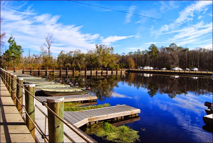
DSC_0162

Coming out of the canal you enter into Billy’s Lake with is a long, narrow lake of about 3 miles in length. For today’s paddle we decided to take a left and head over to Billy’s Island to take the nature walk around that island. It was an easy 2 mile paddle to get there.

DSC_0148

It was an overcast and somewhat grey day, but the wind was down and the temperatures were perfect in the low 60’s.

DSC_0139

This the GPS track of the track we took to get to Billy’s Island.


There’s a dock and boardwalk at the landing, but it was a little crowded with other canoes and motor boats. So, we decided to just pull up on land.
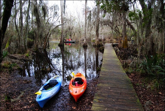
DSC_0117

Here is a photo sphere picture of the docking area at Billy’s Island.

Billy’s island was originally inhabited by local Native American's, but later became a small town where many working the lumber industry lived. Back in the early 1900’s there were attempts to build canals and drain the swamp to make timber harvest easier. They finally abandoned that idea and the town on Billy’s Island ceased to exist. But before they gave up, a lot of the swamps cypress trees were cut and hauled out by train on tracks built to cross the swamps.

There’s not much left of the town on Billy’s Island, but theirs is some old pieces of equipment scattered here and there. Also, there is a small cemetery located near the boat docking area.

DSC_0123

The hiking trail on the island is relatively short at three quarters of a mile. Below is the GPS track of this hike.


On our paddle back to the state park, we took a few side trips in the small creeks that lead deep into the swamp. These creeks are not marked and after your go a short distance you realize how easy it would be to get turned around and loose your way. When hiking or paddling we always carry a GPS and track where we’ve come from. Hopefully making it unlikely we’d get turnaround and lost.

DSC_0132


While paddling around these back areas, we encountered many flocks of birds and had a few owls screeching back and forth to each other. Besides the birds, there really is no other outside noise. Really a pretty cool experience.
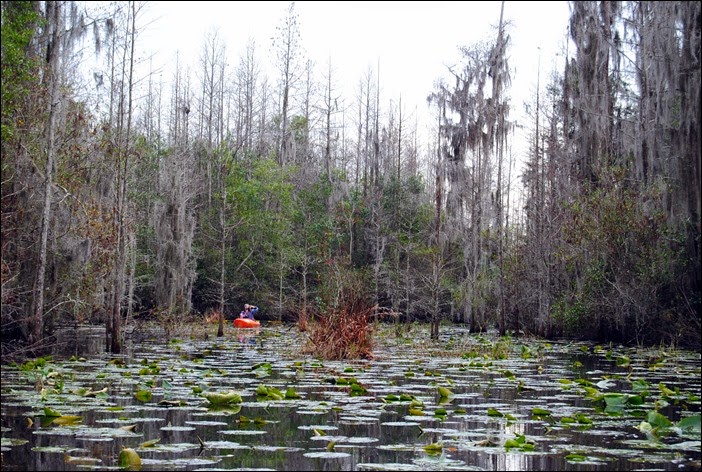
DSC_0136

And our GPS track from Billy’s Island back to Stephen Foster State Park


On Sunday morning we found the boardwalk that begins behind the visitors center and heads off into the swamp. After about a quarter mile the boardwalk ends, although you can see old sections leading off into the distance. Probably a victim of the fires that ravages these swamps a few years ago.

DSC_0156


The Okefenokee Swap is huge, taking up about 440,000 acres straddling the Florida/Georgia boarder. Back in 2007 a lightening strike started a wild file that consumed over 600,000 acres in the area, including vast areas within the Okefenokee swamp. Another large wildfire in 2011 burned other sections of the swamp. As a result, much of the area around Billy’s Lake looks like the picture below. A good article about the fires can be found at this link.

DSC_0154


Here is a photo sphere picture of the end of the board walk looking off into the swamp.

Here is GPS track of our swamp boardwalk hike.


Sunday afternoon we wanted to go further into the swamp than our paddling arms wanted to take us. The park offers john boats with small gas motors for rent. We decided to get one of these boats for four hours.

DSC_0159

We first headed west on Billy’s Lake as far as we could go. We motored about a mile and a half to Mixon’s Hammock where we turned around and then headed east back towards Billy’s Island.

The Okefenokee Swamp is called the land of the trembling earth, for all of the floating islands of vegetation. But it should also be called the land of many gators. They were everywhere and we passed one after another as we boated by. And those are just the ones we saw. I’m sure there were an equal number of gators that we didn’t happen to notice. 

DSC_0168


A picture showing the areas of burned out trees from the wild fires that consumed this area.
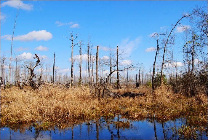
DSC_0170

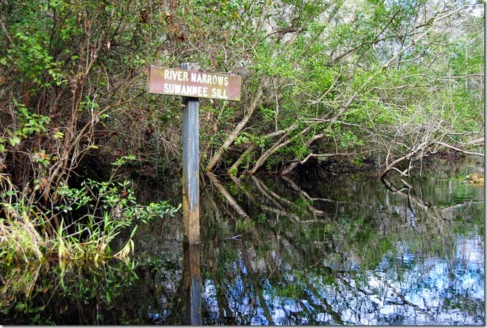
The Okefenokee is the headwaters for the Suwannee River, with about 90% of the water flowing out of the swamp feeding that river. We passed this sign pointing out the Suwanee Sill where the river originates.
DSC_0166


Heading north out of Billy’s Lake we followed a river (or a at times a narrow stream!) that is part of one of the many canoe/kayak trails that wind through the swamp. We had hoped to get as far as Big Water Lake which is the northern most boundary for “day use” activity. But the boating was slow with many twists and turn along the way. And we encountered a somewhat large group of boy scouts canoeing in the opposite direction. It was obvious that they were not ever given any paddling lessons as they were bouncing from shore to shore, with almost none of them heading in a straight line. So, we puller over many times to let them pass and found their antics amusing. Although we did feel sorry for the one group with the canoe that had tipped and they were attempting to tow the submerged canoe the three miles back the dock. A few of the adults in the group looked a little grumpy!!

We did make it to the Minnie’s Lake Rest Shelter. This is a structure above the water built on stilts. It was a good place to get out and stretch your legs and have a little lunch. There were a few other groups there and it was interesting talking with them and hearing about their day.

2015-01-18 13.59.30

Here is the track of our day on the water in the john boat.

Sunday afternoon, after our time on the water, we found a few of the other short hiking trails they have within the park. The Upland trail winds its’ way from the park road, out into an old old pine forest, which is now mostly gone with some young pines now starting to fill in. The only problem is that about three-quarters of the trail is under water. We had out water shoes on, so we decided to forge on and completed our hike.

2015-01-18 16.29.55

And one last photo sphere picture at the half way point of the Upland Trail hike.


And our last hike was the Fitness Trail which boarders the camping loops. Along the way they have some exercises for you to do. Julie did some of them and I watched!!


On Monday morning it was time to pack up and head back home. Julie and I have added this park as one to make a return trip to and do some more exploring sometime in the near future.

Sunday, January 11, 2015

Hiking around Watermelon Pond – Goethe State Forest


Date: 1/11/2015

Location: Newberry, Fl


Did a Sunday morning hike at Watermelon Pond which is part of the Goethe State Forest west of Gainesville.


2015-01-11 13.17.32

2015-01-11 10.55.23


2015-01-11 13.13.16

2015-01-11 13.12.41

2015-01-11 13.08.49


I just started playing around with Google PhotoSphere. Here are a few from today’s hike:


Watermelon Pond Hike #2


Monday, December 8, 2014

Camping with family at Fort De Soto County Park


Date: 12/4/14 – 12/7/14

Location: Fort De Soto, St. Petersburg, Fl


Back in August we were surfing around the campground reservation sites trying to find a location for a December camping trip. For some odd reason we were able to secure two adjoining sites at Fort Desoto Campground in St. Petersburg, Florida. Fort De Soto is a very popular park and difficult to get a spot during the busy season. So, we were surprised to find we could actually get a reservation here.

We’ve camped here once before several years ago and it was right after we bought our trailer. Julie also used to camp here when she was a kid. Her parents and 5 sisters would stay here for a week or so during the summer in the family's’ pop up trailer. I can’t imagine camping with six daughters, but I guess they all survived and actually had a fun time and now fond memories.

Julie and I were hoping we could entice some of our Florida family members to join us for the weekend. We put out the word to family and actually got a few takers. My brother and his wife (Jim and JoAnne) from south Florida along with our two daughters (Allison and Michelle) and a son-in-law (Dave) decided to join us. How lucky were we!! We love having company during our camping trips.

Our sites, # 207 & #208, were right on the water. They were good sized with adequate privacy between the sites, but we didn’t have a great view of the water as there were some mangroves preventing us from getting a good view. Luckily we were able to launch the kayaks from our site. On Saturday the site next to us was open and had a prime water view, so we kind of took it over for a time and hung out there and enjoyed the scenery.

This is site #207 with the matching tents. We really like the tent that Jim and JoAnne have, so when the kids decided to join us, we purchased similar tent from Amazon. When we set them up we realized that they were exactly the same.

2014-12-05 16.35.59


This is our site, #208, right next door. Allison stayed in the tent right behind our trailer, but she felt a little cheated after she saw that her sisters tent had a screen porch. It’s always tough being the younger sibling!!

DSC_0089

Our family enjoys playing corn hole (aka “bags” for those more refined southern family members).  Sometimes these games get a little competitive and the trash talking flows freely. I brought our “corn hole” set up and found a somewhat level area in front of our sites. We got in a few good games over the weekend, but no champions were crowned. That will have to wait for the next ‘Curtis Cup Challenge” held every summer at Maine lake place.

DSC_0088


This guy (or gal?) spent a lot of time in the trees near our site. A very good looking bird, but…

DSC_0087 

he would make periodic trips through our campsites looking for handouts. And he didn’t want to take “no” for an answer. The first day we were there, we ate lunch at the picnic table at our site. This bird walked up to us, stood about 2 feet away from our table and just stared at us. We didn’t give in and he finally walked away, but made many more appearances throughout the weekend.

2014-12-04 16.44.23


One of the great things about Fort De Soto is the number of activities available. It’s really a well designed and run campground. There’s miles and miles of bike trails. One Friday Julie and I took a ride around the park. Here we came across a few white pelicans. It was entertaining watching them chase the fish around this small bay. It was almost too easy for them to catch their lunch.

2014-12-05 10.41.13

The younger generation arrived on Friday night for the weekend camping trip. We were sure lucky with the weather this weekend and Saturday was actually a little warm with the temperatures reaching into the low 80’s. Here’s they are enjoying the water in front of our site. You know it had to be warm for our two daughters to actually be in the water. One (not saying who) is a cold water wimp and won’t go near the water unless it is VERY warm.

2014-12-06 12.43.34


A nice little family pic at sunset of Jim, JoAnne, moi and daughter Allison.

DSC_0097


One one of our bike rides I came across this “RV” as they were checking into the campground. I’m thinking this may be next our list of RV purchases. This thing was a beast and its’ tires came up to my chest. It really was way cool. It had a web site address on it, http://www.monster-worldtour.de/, which I tried to look up. But it was totally in German, so didn’t mean much to me.

2014-12-05 10.25.58


Whenever Julie and I camp with Jim and Jo we split the cooking duties. Here they are preparing another fine breakfast for us. We always eat well when we camp!!

2014-12-07 08.55.31


Jim and I did an early morning bike ride on Saturday and Sunday. Saturday’s ride took us by the fort and over to the west beach area. The picture below is of the lagoons just off the Gulf of Mexico. They have a large area roped off as a bird sanctuary and nesting area.

DSC_0068

Here’s the GPS track of our Saturday ride.

Fort Desoto Campground Bike Ride at EveryTrail


Our Sunday bike ride took us to the east beach area:

Fort Desoto Campground Bike Ride at EveryTrail


The water was calm for most of our weekend trip. Julie spent some time paddling around the bay and enjoying some time on the water.

DSC_0071


Here’s Jim also taking a little paddle around the area. The last night we were there, the weather started to change, the wind picked up some and the fog rolled in. So glad we had good weather earlier so we could enjoy our outdoor activities.

DSC_0103


On Saturday we had some visitors join us. Joanne’s sister Janice and her husband Bill came over from Dunedin and hung out for awhile out by the water. We tried to talk them into staying for dinner, but unfortunately they had to leave.  Later that same afternoon a long lost friend of Julie and I stopped by. Garrett was a co-worker of ours when we worked at Chief Charlies way back in the late 1970’s (wow, that’s a long time ago!!). He’s lived in the area since that time and we re-united with him just recently when we spent a weekend in Dunedin. He now has a beautiful family, his wife Terry and two sons. We hope to see them again sometime soon. 

And one final picture of a sunset from Fort De Soto and the now famous tree. Looking back at the pictures that I’ve included, I think this tree is in about half of them. Guess I really thought it was interesting enough to photograph..over…and…over!!

DSC_0095


A youtube vidoe showing our two campsites.

Thursday, November 13, 2014

Camping at Cloudland Canyon State Park


Date: 11/8/14 – 11/11/14

Location: Rising Fawn, Georgia


On our list of places to camp was somewhere north of us and during the fall where maybe we could catch some fall color. Many years ago we had visited areas around the north Georgia mountains, such as Unicoi and Vogel state parks. Both well known camping locations in the mountains of north Georgia. Just recently I’ve started reading about a campground and park in the very northwest corner of Georgia called Cloudland Canyon. This location is about a 7 – 8 hour drive from our home and about the max we would do for a long weekend. And unfortunately, the only direct way to get there is to drive right through the center of Atlanta which is not always a fun adventure while pulling an RV. But we decided that the long day of travel was worth visiting a park that we’ve never seen before and one that gets great reviews.

With Tuesday being Veterans Day, we decided to take a vacation day on Monday to make it a nice 4 day long weekend. This would allow us a couple days of long driving, but also a few days to relax and explore the park. It turns out we couldn’t have picked a better time weather wise to visit. The nighttime lows were about 40 degrees, with the daytime highs in the upper 60’s to low 70’s. With clear skies and perfect temps, we definitely hit it just right!

We were a little concerned since the online reservation system showed the park was completely full over the weekend and we were scheduled to arrive Saturday afternoon. We were expecting to get one of the leftover, non-prime spots. But we figured if the site was too bad, we would just move on Sunday afternoon when the majority of the campers were leaving.

We arrived at Cloudland Canyon at around 2:00pm on Saturday, checked in and them drove directly to the West Side campground. We heard this camping loop was a little nicer and more spread out than the one on the east side of the park. Within minutes we drove by an open site, only the second open site we saw and it was a beautiful location. No other campsite on the right and plenty of room between this site and the next on the left. We discussed continuing to drive around looking at spots, but decided to not take our chances, so we snagged it!

As you can see from the pictures below, this camping site is very nice and with the bonus of some trees with fall color. Also, on Sunday about half the campground checked out and almost all of the rest left on Monday. So, by that time we had this section of the west loop campground all to ourselves. Very nice!!

DSC_0229


DSC_0234


After we got checked in on Saturday, we rested for a short bit and then decided to check out the day use area and some of the many hiking trails. We heard that this park was unique and offered some amazing views, but we really didn’t realize how awesome it would turn out to be.

Here’s a few pictures looking out over one of the canyons the park is named after. A beautiful view showing some of the fall colors down in the valley.

DSC_0164


DSC_0168


DSC_0173


One of the benefits of camping here, that we appreciated more as the weekend progressed, was the amount of hiking trails they had built all over this park. And also the fact that all were easily accessible from the campgrounds and cabins. They also put in a ton of effort making some of the scenic overlooks accessible and also safe. Like this overlook below with the fence to prevent anyone from falling. Theses type of overlooks were common on many of the trails.

DSC_0181


Of course there were also many spots where you could get close to the edge with nothing preventing you from falling. Here’s Julie doing her best to increase the excitement level some.

DSC_0236


Probably one of the best hikes in the park is the West Rim Loop Trail. This trail winds around the section of the park where we were camped and is an amazing hike. Both Julie and I would rate this as one of the best and most exciting hikes we have ever done. I’d give it the number two spot on my list, right below Grinnell Glacier in Glacier National Park. Julie thinks it rates ahead of that hike, so you can tell we really enjoyed it!

This overlook, looking north out of the park towards Chattanooga, was an example of how much effort they put into giving you places to view the surrounding mountains and canyons. But this one was very slanted and wanted to move you close to the edge where the drop was hundreds of feet. Here’s Julie holding on to the railing while staying away from the drop off.

DSC_0250


Over the years I’ve always snickered at campers who carry their little dog around in a sling or push it in a stroller. Every year we go to the Tampa RV Super Show and I just have to laugh at all the people (mainly men!!!) carrying their little fluffy. Well, this is what I get for laughing at them…..it’s now us!! We have a little grand-doggy who usually stays home with a dog sitter when we go camping, but we decided to try and save a little money and started bringing her along. Julie ordered an over the shoulder sling/pouch so we can take her hiking with us. From the picture below, it doesn’t look like she is too stressed. I actually think she enjoyed it and she sure did get a lot of attention from the fellow hikers we passed along the way.

DSC_0265


Almost all of the hiking trails in the park have a lot of elevation changes, with many of them descending all the way to the bottom of the ravines. We surely didn’t have to worry about getting our exercise during this weekend. On many of the hikes to the bottom there were interesting rock formations and some caves.

DSC_0304


And along the way we passed several high waterfalls. However, Zelda (the dog) didn’t like the waterfalls. Guess all the water noise reminded her of bath time!

DSC_0360


DSC_0372


I probably took a hundred pictures of the view looking out over the canyon. It was just too good to pass up. It did make it a little challenging whittling down the pics to the ones I’d use in this blog entry.

DSC_0396


DSC_0404


At one point Julie took the camera away from me. I think it was after I’d taken the hundredth picture of her and the surrounding fall colors. This is one she snapped of me. I figured I’d add it as it’s one of the few you will see of me here. 

DSC_0421


Over the long weekend, we just about hiked ourselves to death. We are flatlanders from Florida. So, all these hikes and the elevation changes were a great workout. If we had stayed another day, it would have had to be a day of rest. We both had tired legs at the end. I figured we did between 20 – 25 miles of hiking over those few days. That’s a lot for two old farts!

Here’s a link to a short YouTube video from this camping trip

And some GPS tracks from some of the hikes we took

Cloudland Canyon’s Overlook Trail Hike on Wikiloc and EveryTrail

Cloudland Canyon’s West Rim Loop Trail on Wikiloc and Everytrail

Cloudland Canyon’s Waterfall Trail on Wikiloc and Everytrail

Cloudland Canyon’s Sitton Gulch Trail on Wikiloc and EveryTrail